Welcome to the second of a two part series chronicling the adventures of my wife, Maureen and I as we followed the Red Coat Trail across the Prairies. The Red Coat Trail is a series of provincial highways, which more or less followed the route taken by the North West Mounted Police back in 1874 on their march west from Manitoba to Southern Alberta. Maureen and I however, were going the other way. Our starting point was Fort Macleod in Southern Alberta and we were headed east. By the end of part one, we had reached the middle of Saskatchewan. Along the way, we had visited some interesting attractions, driven over some unique roads and experienced some very empty yet beautiful landscapes. In part two, we continued east along the Red Coat Trail to its end, near Winnipeg, Manitoba. Please join us for the rest of our adventure.
 |
| Red Coat Trail Map - Part 2 |
The Kindness of Strangers?
Assiniboia was the next large town along Saskatchewan Highway 13 (which the Red Coat Trail followed) past Shaunavon. After several hours on the road, it was a perfect place to stop for a stretch, some gas and a coffee. As we rolled into town, I spotted a Co-Op gas bar and pulled in, only to find all the pumps occupied. There was nothing to do but wait. When the vehicle ahead of me finished and drove away, I began pulling forward. From out of nowhere, a woman in an SUV cut in front of me and took my spot at the pump. By the time I had recovered from the shock and astonishment over what had just happened, she was out of the vehicle and pumping fuel. Apparently she hadn’t gotten the memo about friendly and hospitable prairie people.
 |
| Downtown Assiniboia |
 |
| Storm Clouds Ahead |
So far on our trip, we had been lucky with the weather. The occasional rain show and little more. Near the village of Ogema, about 40 km east of Assiniboia, our luck ran out. There, we hit a torrential downpour that thought it was a hurricane. The winds were fierce, the road was slick and visibility was almost nil. Had there been a place to pull off, I would have parked in an instant. Unfortunately, there were none so the only option was to keep going. I slowed to a crawl, put on the flashers and hoped for the best. Even at a snail’s pace, it was difficult to keep the rig on the road.
The downpour lasted for about 20 minutes though it seemed like an eternity. Then, as quickly as the storm had enveloped us, it was gone. Later, while listening to the news, we learned that funnel shaped clouds had been spotted near Regina, just north of us. On the plus side, the layer (and it was a thick) of bugs that had plastered themselves to the front the trailer was all but gone. The rainstorm had done a better cleaning job than a pressure washer.
Wonderful Weyburn
By the time we reached Weyburn, the next large town on the Red Coat Trail, the rains had ended and a few rays of sunshine were peeking through the clouds. Much nicer conditions for setting up camp.
After passing through so many small villages and hamlets, Weyburn came as a bit of a shock. With traffic lights, a mall, a large downtown area, a Walmart, and a Canadian Tire, it seemed like a veritable metropolis. The “piece de resistance” however was a Tim Hortons. Travelling the byways and back roads was a great way to see the country but, it did mean forgoing some urban pleasures so, it was positively blissful to once again savour the delicious taste of a large “Ice Cap”. As if all that wasn’t enough, Weyburn also had a very nice municipal campground situated within a large public park along the Souris River. With wide spaces, full services including WiFi, a location close to downtown and reasonable rates, it had everything we desired.
 |
| Weyburn Municipal RV Park |
 |
| Saskatchewan's Oil Patch |
Changing Landscapes
Something else that had been increasing and continued to increase as we rolled east were trees. Before Weyburn, the landscape had been typical prairie with endless fields and few trees, most of which had been planted by farmers as windbreaks around homes and farm buildings. East of Weyburn, that started to change. We began noticing small woodlots and forested areas dotting the landscape. Most seemed to be natural rather than “man made”. The further east we drove the larger, the more numerous these forested sections became. By the time we reached the end of the Red Coat Trail near Winnipeg, we were seeing some good-sized woodland areas. Geographers called this a transition zone between the heavily forested Canadian Shield region east of Winnipeg and the relatively treeless prairies of Southern Saskatchewan. Travellers called it a pleasant visual change.
Redvers
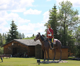
The village of Redvers, near the Manitoba border was on the edge of this transitional zone. It was also one of the few communities to take advantage of its location on the Red Coat Trail by erecting a huge statue of a North West Mounted Policeman on horseback outside its tourist office. Being beside the highway, the statue was a magnet for the curious - like me - who could not resist a unique roadside attraction. It was the tourist bureau however, that was the real attraction. Besides having what looked like a very nice campground near by, the office featured an extensive collection of items created by local artists. For example, I picked up a marvelous children’s book for my granddaughter called “Penelope: The House of Pretend” about a playhouse and the lives of the children who grew up playing in it. The book was written by local authors, Zelda Luchenski and Nona Faye McMillan and illustrated by Ione Krainyk. What made the book so special was the fact that I could actually see the playhouse and perhaps even meet the authors by visiting the village of Fairlight, just north of Redvers. Try doing that with your Tom Clancey or John Grisham novels.
 |
| North West Mounted Policeman on Horseback - Redvers |
Crossing the Manitoba border brought another highway change but little else. Saskatchewan Highway 13 became Manitoba Highway 2, which the Red Coat Trail now followed. The road itself however, continued to be straight, smooth and lightly travelled.
Once into Manitoba, the rain clouds returned. By the time we reached the town of Souris, about 45 km east of the border, it was pouring “cats and dogs”. I had hoped to stop and explore the town, which boasted a suspension bridge that was supposed to be quite famous. When faced with the choice of going outside in a downpour or staying inside a warm dry truck cab, the truck won out.
 |
| Souris Suspension Bridge on a Sunny Day |
Commonwealth Air Training Plan Museum
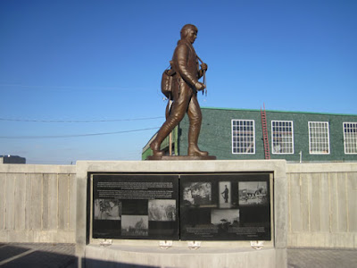
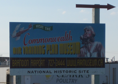
About 15 km east of Souris was the intersection of Highways 2 and 10. Highway 2 (The Red Coat Trail) continued east. Highway 10 ran north to the city of Brandon, about a 15 km distance. Brandon was our destination for a brief side trip. On a corner of the city’s airport was the Commonwealth Air Training Plan Museum, which I wanted to visit. This museum contained a collection of World War II vintage aircraft used to train aircrew as part of the Commonwealth Air Training Plan. Housed inside a vintage World War II era hanger was their collection of aircraft and wartime memorabilia. Outside was a memorial to all the fallen airmen who had been part of the Commonwealth Air Training Plan. Both the museum and memorial were truly impressive and worth a visit.
 |
| Commonwealth Air Training Plan Museum |
 |
| Commonwealth Air Training Plan Museum Aircraft |
 |
| Commonwealth Air Training Plan Memorial |
Not so impressive was the city of Brandon. Although it did have a pleasant RV park just outside of town on the TransCanada Highway, its commercial and business districts were chopped up and scattered about. Along the TransCanada Highway for example, were a number of hotels, gas stations, dealerships, garages, stores and restaurants. Just south of the TransCanada Highway on Highway 10 was a large plaza, anchored by a Walmart. Further south along Highway 10, just past Brandon University was another large shopping area with several strip malls and big box stores such as Super Store and Home Depot. East of the university was the downtown core with its own mall and shopping area. Throw in some one-way streets, a little road construction, a few detours and it all added up to a very confusing environment for visitors.
Multicultural Manitoba
Returning to Highway 2 and the Red Coat Trail we continued east. As we rolled along, we noticed the land had become very flat. While a lot of people think of the Prairies as being flat, that’s not entirely true. The Prairie landscape consisted mainly of rolling hills. The really flat land was in southern Manitoba where hardly a hill or rise could be seen. This may be great for farming but, its disasterous during a flood. A river (and several flow through the region) had only to overflow its banks by a slight amount to cover hundreds of square kilometers. There’s nothing to stop the water.
 |
| Holland Manitoba |
As in Saskatchewan, the Red Coat Trail passed by a number of villages and hamlets with names like Holland, Treherne and Notre Dame de Lourdes. Each community reflected the unique culture and character of the group (Irish, Scottish, French, Metis, Icelandic, Mennonite, etc.), which first settled the area. A good example was the village of St Claude. Settled by French immigrants over a century ago, it featured a beautiful Roman Catholic Church designed by the same architect who planned the cathedral in St Boniface. In a nearby park stood a huge smoking pipe (second largest in the world), which commemorated those settlers who came to the area from Saint-Claude in France, where the main industry was the manufacturing of smoking pipes. Not far away was the Dairy Museum of Manitoba which honors of the area’s main industry.
 |
| The Huge Smoking Pipe at St Claude |
St Claude Cathedral
 |
| Junction of Manitoba Highway 100 and Highway 2 End of the Red Coat Trail |
Sadly, as all journeys must, this one came to a close at the intersection with Manitoba Highway 100, the perimeter road circling Winnipeg. That marked the end of Highway 2 and the Red Coat Trail. Reflecting back on our excursion along this historic route, it was interesting to ask if the Red Coat Trail had lived up to our expectations? Had it given us a chance to explore a part of the country largely overlooked by tourists, to view new landscapes and attractions bypassed by the TransCanada Highway and to experience local culture? The answer was a resounding, “Yes”! It had shown us a part of Western Canada we had never seen before but would definitely enjoy visiting again. To misquote Arnold Schwarzenegger from the movie “The Terminator”, “We’ll be Baack!”


No comments:
Post a Comment